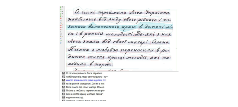
Das MultiHTR-Team setzt die Ergebnisse der ersten erfolgreichen Projektphase (01. Juni 2020 bis 31. Mai 2022) fort, um in der
Short description of the project
HGIS de las Indias is a historical-geographical database of late colonial Spanish America. It contains over 15,000 settlements and over 1,000 administrative units with their qualitative, spatial, and temporal attributes. This allows querying and visualization of the constantly changing situation for any given moment between 1701 and 1808. A Dokuwiki apparatus and a dynamic WebGIS enable this through online interfaces (the website is in Spanish), with all raw data and datasets available on the Harvard Dataverse. The database is also integrated into generalized infrastructures (WHGazetteer; Recogito/Pelagios). Geomatching workflows allow efficient identification and localization/spatialization of structured, tabular datasets.
Project content
HGIS de las Indias is a historical-geographical information system for late colonial Spanish America (1701-1808). Its core is an interactive WebGIS that allows visualization various layers of information on colonial history year by year via a timeline. Key elements include territorial units (such as viceroyalties, judicial districts, provinces, dioceses...) as areas and boundaries; settlements visualizable by different criteria (settlement type, ecclesiastical hierarchy...); communication infrastructure (postal routes); "extracolonial" elements (contract lines, claims of foreign powers, autonomous indigenous peoples, internal and external conflict); historical natural events (earthquakes, volcanic eruptions); and other aggregated data from various fields such as demography, economy, and culture.
The interactive map is linked to a dokuwiki resource providing additional information on each data layer, sources, and term definitions. Additionally, each territorial entity (over 1000) and each recorded place (over 15,000) of the gazetteer has a dedicated page with essential information, indicating sources, lists of administators, and more.
All data from HGIS de las Indias are accessible under a Creative Commons 4.0 license at the Harvard Dataverse. Furthermore, HGIS de las Indias offers the possibility to convert custom tabular data (having a minimum level of standardized fields and thus can be assigned to locations/territorial units in the database) into shapefiles through an automatic workflow.
The project targets a broad, Spanish-speaking audience (via the web application, wiki resource), colleagues with GIS user skills (by providing vector data), and those without GIS user skills (through the automated workflow and web application).
Both WebGIS and Dokuwiki are currently in a relocation process/being rebuilt. The core WebGIS is functional and specialized experiences are being developped step by step. The Dokuwiki has become too large and therefore very unstable. We are planning to use a different, open data approach to make the apparatus accessible again.
By systematizing historical-geographical information as a gazetteer, HGIS de las Indias also serves as infrastructure for other projects (digital editions, collaborative databases). For example, in the ongoing TopUrbi – Topographie de l’urbanisation impériale hispanique (ANR-21-CE27-0023) led by Jean-Paul Zuñiga, a digital edition of Antonio de Alcedo's five-volume geographical dictionary from the late 18th century is being created. The places listed therein are matched with the HGIS-Indias database for localization. A collaboration with José Antonio Espín-Sánchez at the Economic Growth Center at Yale University aims to provide a long-term perspective for preserving the central resources of HGIS-Indias and creating a data ecosystem that connects various socio-economic and demographic data.
werner.stangl@uni-graz.at
Find out more at
www.hgis-indias.net
Add your DH research project to the project showcase by submitting a short project description via the web form. Enter project data, a brief description, a graphic or visualization as well as a detailed description of the project content with technical assignment, addressees, added value, project managers, funding information and duration.

Das MultiHTR-Team setzt die Ergebnisse der ersten erfolgreichen Projektphase (01. Juni 2020 bis 31. Mai 2022) fort, um in der
is in die 1990er Jahre war es in der Filmwissenschaft ein Gemeinplatz, dass Frauen in den Anfangsjahren der Filmproduktion nur

Das Forschungs- und Lehrkorpus Gesprochenes Deutsch (FOLK) wird seit 2008 am Leibniz-Institut für Deutsche Sprache aufgebaut. Das Korpus enthält Audio-
Das DARIAH-DE Repository ist eine zentrale Komponente der DARIAH-DE Forschungsdaten-Föderationsarchitektur, die verschiedene Dienste und Anwendungen aggregiert und so komfortabel nutzbar
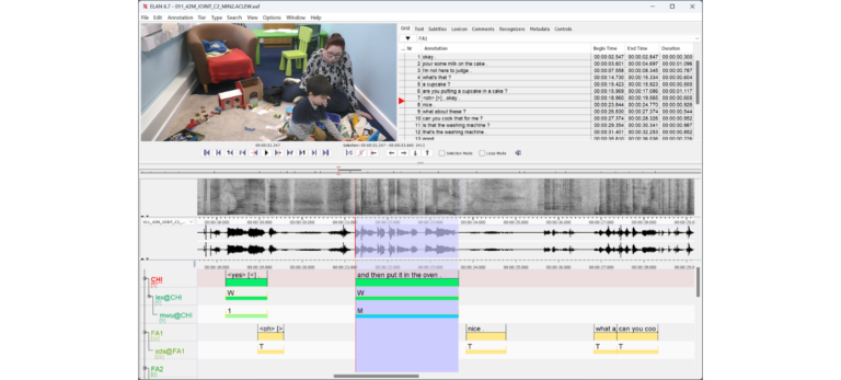
ELAN wird am Max-Planck-Institut für Psycholinguistik im Sprach-Archiv (TLA – The Language Archive) entwickelt. Es wird in der Programmiersprache Java

Mit Dietrich online werden bibliographische Angaben zu ca. 5. Mio im deutschen Sprachraum von 1897- 1944 erschienenen Zeitschriftenaufsätzen und Zeitungsartikeln
Arthur Schnitzler gehört zu den bedeutendsten österreichischen Autoren und war ein produktiver und gut vernetzter Briefschreiber. Seine Korrespondenz wurde jedoch
Die Virtuelle Forschungsumgebung TextGrid ist optimiert für die digitale Erschließung geisteswissenschaftlicher Quellen und deren langfristige Archivierung in einem Web-Archiv, insbesondere von TEI-codierten Ressourcen
Wir verwenden Cookies und ähnliche Funktionen zur Verarbeitung von Daten. Die Zustimmung ist freiwillig und kann jederzeit widerrufen werden.